Henry Lyatsky has a message for those who explore for oil and gas. As a practicing geophysicist and geologist, this Calgary researcher and consultant is intimately familiar with both professions and has observed the two often don’t converge enough—especially when it comes to basement geology.
“If you want to understand your basin, begin with the basement,” he says. While most geologists in the oil and gas industry recognize this, geophysicists can overlook it in their fixation on the all-important seismic.
Lyatsky sets the picture: “When you are dealing with oil and gas you are dealing with sedimentary rocks which are stratified, kind of flat-lying,” he says. They have relatively uncomplicated structures where seismic methods are ideal. “But when the rocks are all skewed and confused you don’t know what you are getting.” He explains that the sedimentary basin is a geological body; a body of rocks sitting on top of another body of rocks that is commonly a crystalline basement. “It’s like putting a bunch of stuff on top of a table,” he says. “It’s affected by what the table is. If the table is not very steady or is shifting it’s going to shift what’s higher up. So you have to think about the crystalline basement which is not sedimentary but highly metamorphosed; often igneous.”
These are the rocks that mining explorers are accustomed to, says Lyatsky; they are faced with a different rock mass requiring different geophysics. “The rocks are more diverse than you find in oil and gas exploration,” he says. So they rely on a wider range of geophysical techniques that includes magnetic, gravity, electrical, electromagnetic and radiometric.
However, seismic remains critical, indeed indispensable, to oil and gas explorers. But to fully interpret it, geophysicists should have a good knowledge of basement faults and fractures, which have a way of propagating up the sedimentary section. “They affect your depositional patterns, your erosional patterns, your compaction and alteration patterns, your facies distribution, your secondary porosity, your salt dissolution,” advises Lyatsky. “All of these are affected and sometimes controlled by those fractures coming from the basement.”
And basement rocks are not exposed although they can often be seen around the fringe of a sedimentary basin. “But you don’t actually know it,” says Lyatsky. “You don’t see it so you have to be very cautious in making your interpretations—you don’t want to go around inventing things. You have to be very conservative but you have to squeeze every drop of blood out of the stone. And what matters more than anything else are those faults and fractures that are in the basement.”
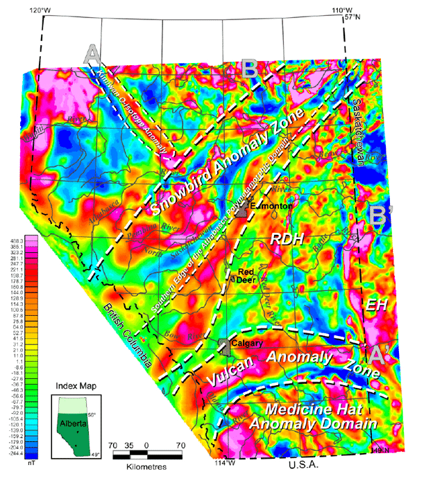
To know these, you pretty much have to look at gravity and magnetics, says Lyatsky, especially in a mature basin like the Alberta. But not only in mature basins: “If it’s a frontier basin it depends on the basin; if there is a lot of structure or vertical displacements and faults, I still use a mix of gravity and magnetics.”
Gravity and magnetic data are available free of charge from Canada’s federal government. “The cost is zero. And if the basement is deep enough, in most of the Alberta basin for example, government data are sufficient for probably 80% of the basin to resolve all of your basement anomalies,” says Lyatsky. Around the edges of the basin, for example in northeastern Alberta, it may not be sufficient so flying tighter surveys may be in order. “But before you do that and commit capital, spend a fraction of that cost and go over the government data, then you can make your decisions,” he says. “Chances are you will save a ton of money.”
To assist explorers in doing this, Lyatsky has collaborated with the Alberta Geological Survey to publish a gravity and magnetic atlas of basement structure in central and southern Alberta, all from publicly available data (AGS Special Report 072). “I saw a need for it,” he says. “Gravity and magnetic work has been done in this basin since 1947—the original publications were coming out in the 50s. People thought Leduc must be sitting on a basement fault of some kind. That particular fault is found more by gravity than magnetics.” But as time went on it became too academic, he says. So as someone who could straddle the academic and commercial geophysics, he pulled it together in a more readily useable format.
To use it with seismic data, he has some suggestions for oil and gas geophysicists. “When it comes to integration of the data, you’ve got to start thinking like a geologist,” he advises. “Stop thinking like a physicist because the purpose is to get geological information—so at some point you have to switch to the geology mode.” Trained in both, he usually helps his clients with that as a project progresses. “Geologists come in and say, what am I supposed to do with this? You begin to tell them in their own language—to avoid the disconnect—saying this is what it can do for you.”
For geophysicists, Lyatsky points out that in platformal basins like the Alberta or the Williston, a lot of the basement fractures and faults have too little vertical offset to be visible in seismic displays at all. “Lineament maps compared with the known geology of play intervals in the sedimentary section might suggest basement control if something linear in the play interval lines up with basement-sourced lineaments,” he says. For example, if a linear string of oil or gas reservoirs coincides with a gravity or magnetic basement lineament and this lineament continues beyond the reservoir string, it might be worth asking if there is fault control on the reservoirs and if more reservoirs might exist along the continuation of the basement lineament.
To integrate the gravity and magnetics with seismic data, “the best piece of integration software is the human brain,” says Lyatsky. But he also uses Geosoft routinely. “I used it to make the atlas, and I use it commercially. If you are working to make maps for extracting subtle anomalies, from what I have seen there is nothing better. You have a lot of processing options and they are very good.”
A good picture of the basement is important when it comes to the newer technologies, particularly horizontal multistage fracking—where a liquid, usually water, is blended with a proppant and other substances and injected at high pressure to fracture tight formations like shale and release oil or gas. “We are spending billions of dollars on fracking and that is how you produce [these formations],” says Lyatsky. But with a more intimate knowledge of the basement structure, parts of it may already be fracked. “If you are fracking you want to know what fractures already exist. You want to understand where Mother Nature put her own fractures before you start coming in and spending money to make your own—a lot of that is controlled from the basement up. So every kind of level you look, the more you know about the basement, the easier it is to explore the basin.”
He says it’s good for all formations: primary porosity, secondary porosity, conventional, unconventional, tight. “You are pumping your fluids in, you want to know where they’re going to go. Secondly if it’s already fractured maybe your strategy should be different.” Basement knowledge goes for oil sands applications, too; another unconventional resource, especially with respect to in situ techniques. “With in situ [such as SAGD, or steam-assisted gravity drainage] you don’t dig, you drill and loosen up the bitumen with steam to produce it from a well. You want to know where your faults and fractures are. You are putting fluids into your formation, will they go where you want?”
So how should the industry steer oil and gas geophysicists to the basement, so to speak? Lyatsky reckons you need to start at the beginning of their education. “You go to people who train students and you tell them ‘you guys are doing a, b and c; what we think you should be doing is x, y and z as well as a, b and c’,” he says. “When academics talk to industry, I think it’s the opportunity to tell them what they need to hear. The second thing is, you do it on the demand side; you go to the students themselves.” He never misses a chance to talk to students, and advocates telling them that what they’re getting is constraining their careers and doing them a disservice in the long run.
It has been said that everyone should learn to recognize their faults. Adding to that, Lyatsky has another message for oil and gas geophysicists: “You cannot get away from having to understand your basement faults.”